Mt Clear

35kms (4hrs 55min)

150404_P1000649_export

Backburning in the north western section of Namadgi National Park and Bimberi Wilderness area thwarted our plans to hike Bimberi Peak this weekend.

Instead we headed to the south of the park and tackled a tough run from Mt Clear Campground to Long Flat, Mt Clear, Horse Gully Hut and returning along the Nass River Valley.

Map

East Hills to Sydenham

22.2km (2hrs 37min)

150328_DSC02247_exportA busy weekend saw us tackle an urban run on Saturday morning instead of our usual search for a bush trail.

We caught an early morning train to East Hills and wound our way back east through the suburbs to Sydenham Station. Along the way we discovered a beautiful rainforest corridor single track between Bardwell Park and Wolli Creek (part of the Two Valley Trail) – complete with a chatty flying fox colony and wetland.

It appears part of this corridor is threatened by the WestConnex motorway proposal: the western end of the corridor is an easement for a second M5 East Tunnel, and would be disrupted by the proposed ‘cut and cover’ construction method

For more on the Two Valley Trail which runs from Bexley North to Campsie via the Wolli and Cooks River Valleys:

http://www.wollicreek.org.au/tvt/index.htm

And a summary of the issues regarding the WestConnex and its impact on the Wolli Creek Valley:

http://www.wollicreek.org.au/wolli_valley/issues/westconnex-the-impact-on-wolli-creek-valley

Map

Newnes to Glen Davis return

20.6km (3hrs 33min)

150321_IMG_0438_exportBilly had come across details on a training camp for the Glow Worm Tunnel Marathon that was going to break the event into two ~20km runs held over this weekend. We thought this was a great training approach, and would be a fun way to meet some fellow trail runners.

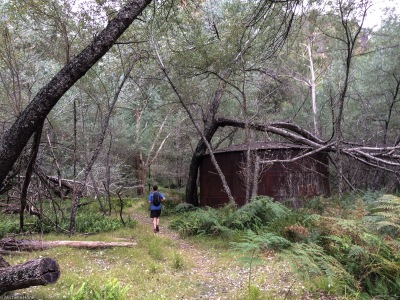
We started out early from Sydney on Saturday morning for the 3hr drive to Newnes, an abandoned shale oil mining site in the Wolgan Valley, west of Sydney.

There’s a great car-camping site at Newnes, nestled beneath a tall escarpment, and we explored the area looking for signs of other runners (also discovering another campsite across the Wolgan River). Unfortunately, we never found the training camp, but headed out ourselves towards Glen Davis along the Pipeline Pass trail.

First along the flat of the Wolgan River, passing a few pieces of rusted industrial debris, then a steep climb up the escarpment to stunning views down the Wolgan Valley. We turned north, and enjoyed a more gradual decline to Glen Davis in the Capertee Valley; Billy brushing aside sticky spiders webs as we made the first descent of the day.

It was interesting to see the boom and bust of this small town through black and white photos on the local community recreation hall. During the war era, the government supported the shale oil refinery to provide an independent source of fuel – grossly uneconomic post-war and without subsidies. Roads, houses, a post office and pub appeared. But the town and the industry eventually petered out (sinking a few $ in the interim). Now there’s a caravan park of retirees.

We didn’t linger long, and after a bit of refuelling, started back up the steady incline home. A great, challenging run for us with over 900m of climbing to test the legs!

Map

Wentworth Falls

19.9km (3hrs 30min)

150314_IMG_0432_exportWe’d been too late to register for the Running Wild race at Wentworth Falls earlier in the year, but wanted to check out the views (especially those over to Solitary) so decided to test ourselves on the myriad of trails in the area on a quieter weekend.

We started and finished along the Darwin track, which runs alongside Jamison Creek towards the Wentworth Falls lookout. Checking the trail race map, we crossed the creek at Weeping Falls and completed the extra loop to the south east, then tested our legs on the stairs down to Wentworth Pass (going the extra mile past the National Pass turn-off).

Turning west, we passed a small group of day hikers who had paused to feel the spray of the falls, and enjoyed the cool of the rainforest along Wentworth Pass.

Soon enough we were climbing back up to the Nature Trail, alongside Empress Falls, which Billy recognised as a beginners canyon, often the location of SUBW trips. We’ll have to give it a go sometime!

Then it was back along the Overcliff Track to the familiar junction at Wentworth Falls, and back to Wilson Park. I was surprised at how good I felt after such a long run, and plenty of stairs. Hopefully legs are getting stronger! Time for a burger and a coke.

Map

Heading West (to Rooty Hill RSL)

Walk 42kms (~10hrs including breaks)

150221_DSC01631_exportBilly and I head west from Annandale and find ourselves having dinner at the Rooty Hill RSL.

Along the way we passed the ever changing eclectic mix of small businesses along Parramatta Road: second hand furniture, bridal stores, a piano shop, juvenile detention centre, a Swiss Restaurant, bathrooms, lamborghini’s… and a few “unnamed” places.

We discovered the best pulled pork burger in Westmead Tavern, and found the home of Pure FM. We were caught up in the Dragon dancers at the Flemington markets and watched the start of a charity Harley Davidson Ride. There’s a lot going on when you head West!

Kurnell Peninsula

12.5km (1hr 47min)

150215_IMG_0308_exportA shorter run today, but a good one to test the legs on some sandy ground and hot weather. I’d come across this area as part of the Sydney Trail Running Series and thought it would be somewhere different for us to try.

A great rock platform, and salty marshland, and hidden surf break with plenty of surfers. It was a flat track, made interesting by the sand. We returned via the recently closed Caltex Kurnell refinery.

Map

Bantry Bay

16.2km (2hrs 45min)

150208_IMG_0213_exportA 16.2km loop around Bantry Bay – starting off on the Bluff Track which winds its way around the upper reaches; a short diversion down a new mountain bike track, then along the picturesque waterfront stopping to chat to some colourful parrots. We completed the loop through the suburbs of Killarney Heights and a firetrail alongside Wakehurst Parkway.

Interesting to come across an aboriginal engraving site with a large whale and multiple other figures near the parkway – I bet the cars roaring past have no idea what’s only a few meters away.

Map